An interactive history of California’s freeways, redlining and racism
Spanning more than six decades between the 1940s and early 2000s, studies show that the construction of the U.S. Interstate Highway System through populated areas perpetuated racial inequality, weakened social institutions, disrupted local economies, and physically divided neighborhoods.
In an effort to understand and quantify these impacts, research centers across the PSR region — UCLA’s Institute of Transportation Studies and Center for Neighborhood Knowledge and UC Davis’s Institute of Transportation Studies — teamed up to conduct a series of case studies on the histories of freeway construction and the institutional policies that supported it in four California communities: Pasadena, Pacoima, Sacramento, and San José.
An interdisciplinary, community-driven research process
Using a combination of qualitative and quantitative methods, UC researchers investigated the freeway route selection process — and the devastating effects these decisions have had for communities of color in the aftermath.
The study’s focus on equity went beyond research scope. To ensure findings authentically represented communities’ lived experiences, voices from civic leaders and community members were integral both to the analysis and to an external review process of draft project documents.
Researchers compiled findings into a report, accompanied by a policy brief, interactive online storymaps sites, and a journal article, to provide decision-makers and community members with multiple accessible ways to engage with the case studies.
As state and federal initiatives like Caltrans’s Reconnecting Communities program have begun the restorative process of repairing freeways’ effects on neighborhoods, studies such as these are critical to guiding allocation of transportation investments so that a meaningful portion of the benefits flows to disadvantaged communities.
Pasadena
In the 1950s and 1960s, a new route of the Foothill Freeway/Interstate 210 displaced nearly 3,000 predominantly Black residents in Pasadena’s northwest neighborhoods. Meanwhile, an alternate route running along the edge of the Rose Bowl — which would have impacted far fewer people — was rejected.

View of the Rose Bowl showing the proposed “Blue Route”
Pacoima
Widely known as America’s “first Black suburb,” Pacoima had a rich history of activism; however, state planners excluded Black residents from the public route decision-making process, as the Simi Freeway/State Route 118 bulldozed through their community in the 1960s. In stark contrast, whiter, wealthier neighborhoods to the west staged “freeway revolts,” listened to by planners, to spare their communities from the 118’s path of destruction.

Pacoima resident at the Joe Louis Homes, 1951
Sacramento
Once a thriving neighborhood known for its rich ethnic diversity, Sacramento’s West End was the city’s original business district. Over the course of the 1950s through ‘70s, however, a combination of urban renewal and construction of three freeways completely reshaped the city’s landscape and contributed to recurring cycles of displacement for communities of color. Some residents displaced from the West End settled in Oak Park, which was itself later cleaved by freeways.

Redlining map of Sacramento and US-50 alternative routes
San José
Intent on “redeveloping blighted areas,” the City of San José supported the State Bureau of Highways’s plans to construct two highways through the heart of Little Saigon, Little Portugal, and Eastside Mexican neighborhoods in the 1960s through 1980s. While the city’s booming population and housing stock absorbed the majority of displaced residents at the time, Interstates 280 and 680 continue to serve as a barrier between neighborhoods of color and the core of the city.

Councilmember Joe Colla atop the Unfinished US-101/I-280/I-680 Interchange, 1976
Related Material
For more on the histories and legacies behind California’s freeways — including further and future case studies of freeway siting in other parts of the state — visit the UCLA Institute of Transportation Studies website.
Images
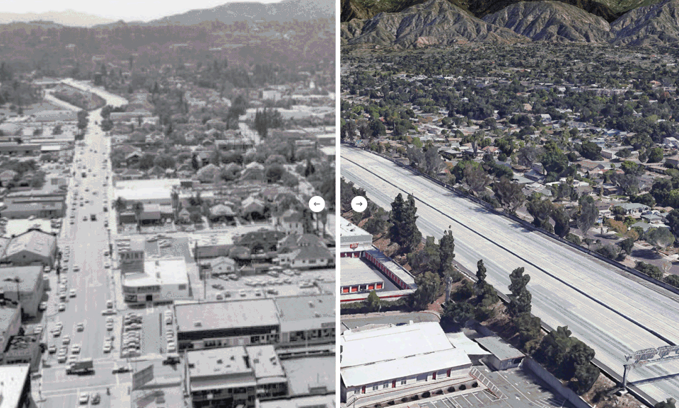
Header (historic): A Dense Street Network Connected Neighborhoods in NW Pasadena to the City’s Commercial West Side Prior to the 210 Freeway, n.d.
Header (present day): Google, 2023
Pasadena: Pasadena Planning Commission and report authors
Pacoima: Pacoima Historical Society, Hodges Collection
Sacramento: Mapping Inequality: Redlining in New Deal America. Digital Scholarship Lab
San José: Mercury News (2013), “Herhold: The Story Behind Joe Colla’s Famous 1976 Highway Stunt”
Related Posts